GeoMedicine - OK, Maybe We Should Move!
The HWN Team | Cutting Edge

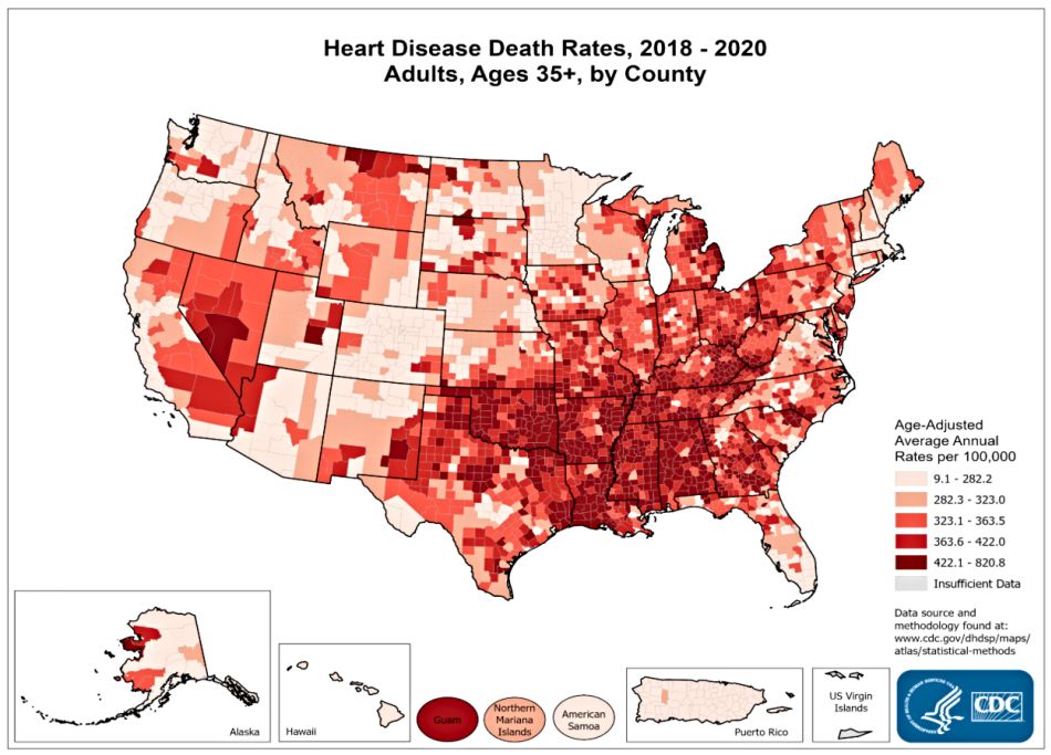
image by: CDC.gov
GeoMedicine will probably serve as a catalyst for future human migration from one part of the globe to another in the quest for minimizing personal health risks. And, it may be sooner than you think!
We have all heard about Global health. But what about GeoMedicine? Why are women in Arkansas seven times more likely to have heart disease than women in Colorado? Why is multiple sclerosis less prevalent in the tropics and subtropics compared to the temperate regions? Why do suicides spike up in Greenland in the summer time?
These are some of the questions addressed by the field of research called geomedicine, an emerging medical specialty. Geomedicine (geography + medicine), defined as "the science dealing with the influence of ordinary environmental factors on the geographical distribution of health problems in humans and animals." is not new but has recently been given a boost due to technological advancements.1
The H1N1 flu scare of 2010 showed how technology has made it possible to trace the spread of disease globally almost in real time. However, GeoMedicine not only deals with epidemics, but also with the long-term effects of the environment on human health. The environmental factors that affect our health may be natural or anthropogenic.
Natural Sources that can disrupt our health include:
Sunlight
The sun is the source of life for this earth, but too much or too little sun exposure brings on health problems. And exposure varies with geography.
The most common health problem associated with exposure to UV rays of the sun is skin cancer. Radiation levels from the sun vary depending on geographic location, time of the year and the weather. In the Southern Hemisphere, the ozone layer is thinner and there is less air pollution to block the summer sun. Hence, skin cancer is highly prevalent in Australia and New Zealand. But the summer sun also presents danger to those in the northern hemisphere.
Too much or too little sunshine, hence daylight has signifigant psychological effects. The so-called seasonal affective disorder (SAD) or winter blues are rather common in the higher latitudes during the dark winter months. However, incessant daylight during the summer months in these regions is also linked to psychological problems such as increased suicide rates due to sleep disorders.2
Study author Karin Sparring Björkstén of the Karolinska Institute in Sweden wrote: “In terms of seasonal light variation, Greenland is the most extreme human habitat. Greenland also has one of the highest suicide rates in the world. We found that suicides were almost exclusively violent and increased during periods of constant day. In the north of the country, 82% of the suicides occurred during the daylight months (including astronomical twilight)".3
Sunshine is the main source of the essential vitamin D, also called the sunshine vitamin. This vitamin is not easily available from the food we eat and can only be synthesized by the body when exposed to sunshine. Thus, people who live in regions with little sunlight tend to suffer from vitamin D deficiency, a condition that is linked to many health problems, especially musculoskeletal disorders. However, even those residing in sunny regions can suffer from vitamin D deficiency if sunlight exposure is avoided. In Middle Eastern countries, for example, Vitamin D deficiency is highly prevalent, especially among women, probably due to less sun exposure as a consequence of cultural and religious practices.4
Researchers observed that multiple sclerosis (MS), which has a strongly genetic component, cannot be explained by heredity alone. There are geographical variations in the incidence of MS, with lower frequency in tropical compared to temperate areas. Climate and sunshine may be involved since MS risk changes when people move from one region to another.5
Similarly, high incidence of myopia or shortsightedness among residents of the Asia-Pacific region has been linked to underexposure to sunlight. Sunlight is said to induce the release of dopamine that inhibits excessive eye growth leading to myopia.6
Pollens and other natural airborne allergens
Those who suffer from hay fever are aware of the seasonal cycle of these natural airborne allergens. Molds are also a major source of allergens, especially in the fall and winter time. However, the kind and amount of pollen and mold spores varies geographically and seasonally.
Radon
Radon is a colorless, odorless, tasteless radioactive gas that occurs naturally. According to the EPA, radon is the leading cause of lung cancer deaths among nonsmokers in America and claims the lives of about 20,000 Americans each year. Radon is released from natural rocks and soil when uranium, a naturally-existing radioactive substance decays. This means that radon may be present in your home or work place. Radon levels vary from place to place.
Soil and water
Substances present in the soil and water can get into the food we eat. When food is deficient in certain nutrients, this deficiency translates to our diets. For example, iodine deficiency is more prevalent among those who live far from the sea, primarily because of diets low in fish and seafood. And, elements such as cobalt, copper, iodine, manganese, and selenium may be deficient in the natural soil, leading to deficiencies in the local population. On the other hand, excessive levels such as those of arsenic can result in poisoning and toxicity.7
Pathogens
Many infectious diseases, including malaria, yellow fever, and sleeping sickness are concentrated in tropical areas and thus restricted geographically. There are however, infections such as HIV and the seasonal and food-borne diseases like salmonellosis that seem to be cosmopolitan with some areas at higher risk than others. Africa, for example, is a high-risk area for HIV infection.
Besides having to cope with our natural environment, we now have to deal with anthropogenic or man-made sources primarily in our water and air.
Water Pollution
Despite waste water treatment procedures in most developed countries, potentially harmful compounds still get into natural waters. Some of these are herbicides and pesticides but also pharmacological agents used in the treatment of common human diseases. Canadian researchers, for example, detected the anti-cholesterol drug bezafibrate and the anti-hypertension agent enalapril in the treated waters released into the St. Lawrence River. The concentrations are minimal but their effects on plants, animals, and people are not known.8
Eventually, some of these compounds find their way into our tap water that ends up in that glass of water that we drink. The Southern Nevada Water Authority in Las Vegas screened tap water from 19 U.S. water utilities between 2006 and 2007.
Of the 51 different compounds screened for, the 11 most frequently detected compounds are as follows:9
- Atenolol, a beta-blocker used to treat cardiovascular disease
- Atrazine, an organic herbicide banned in the European Union, but still used in the U.S, which has been implicated in the decline of fish stocks and changes in animal behaviour
- Carbamazepine, a mood-stabilising drug used to treat bipolar disorder, amongst other things
- Estrone, an oestrogen hormone secreted by the ovaries and blamed for causing gender-bending changes in fish
- Gemfibrozil, an anti-cholesterol drug
- Meprobamate, a tranquilizer widely used in psychiatric treatment
- Naproxen, a painkiller and anti-inflammatory linked to increases in asthma incidence
- Phenytoin, an anticonvulsant that has been used to treat epilepsy
- Sulfamethoxazole, an antibiotic used against the Streptococcus bacteria, which is responsible for tonsillitis and other diseases
- TCEP, a reducing agent used in molecular biology
- Trimethoprim, another antibiotic
Of interest the U.S. government regulates the levels of pathogens and certain pesticides in drinking water, but there are no existing regulations for pharmaceuticals and other compounds. Essentially, water pollution remains a serious threat to all of us.
Air pollution
Studies have shown that urban dwellers suffer from more health problems than those who live in the countryside probably as a consequence of air pollution. Traffic-related air pollution in California and other urbanized areas in the U.S. has been linked to “increased risks of all-cause and cardiopulmonary. mortality.” Particulate matter pollution has been linked not only to heart disease, but also to respiratory problems, asthma, and allergies.10
Lastly, socio-economic factors determine geographic variations of health problems.
One of the most well-studied diseases in terms of geographical distribution is cardiovascular disease. A study by the American Heart Association’s Go Red For Women released in 2008 reported on the top most and least heart-friendly cities in the U.S. based on rates of cardiac mortality, hypertension and exercise rates. Another study by researchers at the University of Pittsburgh reported that Arkansas has the highest mortality rates due to coronary heart disease in the U.S. and identified race as a major determining factor.11,12
The factors determining these geographic variations, however, are not so clear. One possible factor is access to quality health care. An American survey identified New Jersey, Vermont, New Hampshire, Washington and Oregon as the states which are the best in dealing with and caring for heart attacks, thus resulting in less mortalities and decreased hospital readmission.13
On a global scale, cardiovascular disease trends vary between developed and developing countries. The ongoing study Reduction of Atherothrombosis for Continued Health (REACH) is observing more than 60,000 people in 44 countries. Whereas high educational level is associated with lower cardiovascular risk factors in high-income countries, this pattern does not hold true in low and middle income countries.14
So, what can we do? Currently, several tools are available to help you assess your current risks as well as your past exposure.
Explore your Place History
One of the most well-known names in the field of geomedicine is Esri, the geographic information system (GIS) company. Esri has developed the tool “Explore Your Place History” which helps individuals relate their health with current as well as past places of residence.15
One of its managers, Bill Davenhall, a strong advocate of Geomedicine, based on his own personal experience revealed: “Every place I have ever lived and will live is part of my medical history.
The impact of breathing bad air in many of the places I have lived will surely follow me wherever I go, and therefore, my medical record should be augmented with new research findings of relevant health risk.” He believes that doctors “should ask about the geographic information contained within our own place histories in addition to the standard questions regarding genetics and lifestyle”.16
Chemical Hair Imprints
Chemicals identified in fossils and mummies reveal relevant health and environmental information during a certain period of time.
What about markers in our body? Chemicals also leave their marks in our bodies, especially in our bones, nails and hairs where compounds get deposited. In this aspect, the hair is an invaluable source of information of chemical imprints and provides a history of places where we have lived and the environmental chemicals we may have been exposed to. In fact, “depending on its length, a strand can yield several years of chronicled information about a person's whereabouts”.17
American researchers have developed a technique to “ predict the geographic region-of-origin of humans based on the stable isotope composition of their scalp hair.” Hair isotopic composition correlates to isotopic composition of tap water which differs geographically. The water that you drink leaves chemical imprints in your hair and can reveal places that you have been to. In fact, this method is able to detect a move from one country to another! However, in order to leave a hair imprint, a person must stay in one place for at least 3 months.18
Mold and pollen counts
The American Academy of Allergy, Asthma and Immunology (AAAAI), together with the National Allergy Bureau (NAB) provides a tool to inform people of pollen and mold levels depending on location. This is based on results from 85 NAB counting stations in the U.S., two counting stations in Canada, and another two in Argentina.19 Also, the website for the anti-allergy drug Zyrtec gives patients access to allergy forecasts for areas all over the U.S.20
The UV index
The UV Index, developed by the National Weather Service and the U.S. Environmental Protection Agency (EPA), indicates the strength of solar UV radiation on a scale from 1 (low) to 11+ (extremely high). You can use the UV Index to take appropriate sun-protective behaviors and avoid overexposure to UV radiation.21
Flu surveillance
Most developed countries have a flu surveillance network. In the U.S., the Centers for Disease Control (CDC) is responsible for the national influenza surveillance. It gathers data from more than 1500 sentinel doctors who are geographically representative of different regions in the US and its territories.
Google Flu Trends makes predictions about the flu based on the number of people searching for influenza-related topics using the Google search engine. In collaboration with the CDC, Flu Trends identifies geographic areas of high flu activity from “flu search engine query data” on the Internet rapidly, on a daily basis.
“Harnessing the collective intelligence of millions of users, Google web search logs can provide one of the most timely, broad-reaching influenza monitoring systems available today. Whereas traditional systems require 1–2 weeks to gather and process surveillance data, our estimates are current each day. As with other syndromic surveillance systems, the data are most useful as a means to spur further investigation and collection of direct measures of disease activity. This system will be used to track the spread of ILI throughout the 2008–09 influenza season in the United States”.22
Radon Zones
The U.S. EPA has a The U.S. EPA has a map of radon zones and gives homeowner and builders advice on how to test for, mitigate and protect homes from radon. Check EPA’s A Citizen's Guide to Radon and Home Buyer's and Seller's Guide to Radon.23
Air quality monitoring
The American Lung Association regularly publishes the State of the Air Report. The key findings of the 2009 report showed that several California cities are among the 10 most polluted in the U.S. in terms of ozone and particulate matter pollution. The U.S. government set up AirNow, a site which gives up-to-date air quality information (AQI) on a daily basis. Info given includes ozone and particulate matter levels for different geographic areas.24,25]
Travel Advisories
The CDC has a lot of resources for travellers, from the required inoculations to up-to-date travel advisories for your destination. Check out CDC’s Travelers’ Health. Another resource is the online Health Map which allows users to search by disease or by location. Information is also available in different languages.26,27
The Bottom Line
There is no doubt that GeoMedicine will play a major role not only in minimizing personal health risks in areas where we live, but also will probably serve as a catalyst for future human migration from one part of the globe to another. OK, maybe we should MOVE!
Published November 11, 2010, updated May 29, 2012
References
- Davenhall B, Geomedicine: An Idea Whose Time Has Come, ESRI, May 23, 2012
- Servis M, Checkup on Health: Go outside to cure the winter blues, UC Davis Health System
- Kripke DF, Accentuation of suicides but not homicides with rising latitudes of Greenland in the sunny months, BMC Psychiatry 2009, 9:20 (8 May 2009)
- Vitamin D deficiency overview Wikipedia
- Ascherio A, Epidemiology of Multiple Sclerosis: From Risk Factors to Prevention, Seminars in Neurology 2008; 28: 017-028
- Cooper D, Sunlight may save kids' sight, ABC Science
- Steinnes E, Soils and geomedicine, Environ Geochem Health. 2009 Oct;31(5):523-35
- Hypertension And Cholesterol Medications Present In Treated Water Released Into The St. Lawrence River, Medical News Today, 27 Jan 2009
- Hooper R, Top 11 compounds in US drinking water, New Scientist. 12 January 2009
- Ostro B. et al, Long-term exposure to constituents of fine particulate air pollution and mortality: results from the California teachers study, Environ Health Perspect. 2010 Mar;118(3):363-9. Epub 2009 Oct 26
- Press Release. Go Red For Women Ranks America’s Most Heart Friendly Cities for Women, Go Red for Women, American Heart Association, 20 May 2008
- Sekikawa A, Striking Variation in Coronary Heart Disease Mortality in the United States among Black and White Women Aged 45–54 by State, Journal of Women's Health & Gender-Based Medicine. June 2000, 9(5): 545-558
- Chitale R, The Best And Worst States for Heart Attack, ABCNews. 10 Jul 2009
- Miller R, REACH: More education does not always correlate with less CVD, Heartwire. 10 Sept 2010
- Explore Your Place History, Geomedicine, ESRI
- Artz M, Relating geography and healthcare, Geospatial Today
- Courtland R, Your history is printed in your hair, Nature News, 25 Feb 2008.
- Ehleringer J et al, Hydrogen and oxygen isotope ratios in human hair are related to geography, Proc Natl Acad Sci U S A. 2008 February 26; 105(8): 2788–2793
- Pollen & Mold Levels, The American Academy of Allergy, Asthma & Immunology, National Allergy Bureau
- Allergy Forecast, Zyrtec.com
- UV Index, U.S. Environmental Protection Agency
- Ginsberg J et al, Detecting influenza epidemics using search engine query data, Nature 457, 1012-1014 (19 February 2009)
- EPA Map of Radon Zones
- State of the Air 2009, American Lung Association
- AIRNOW
- Travelers’ Health, CDC
- Health Map

Introducing Stitches!
Your Path to Meaningful Connections in the World of Health and Medicine
Connect, Collaborate, and Engage!
Coming Soon - Stitches, the innovative chat app from the creators of HWN. Join meaningful conversations on health and medical topics. Share text, images, and videos seamlessly. Connect directly within HWN's topic pages and articles.


